In Goa, real estate land grab threatens protected eco-sensitive slopes
Goa has a statewide regional plan demarcating slopes where development is prohibited. Introduced to reduce landslide risks, the protection is being systemically diluted.

Right before the Mapusa river meets the Mandovi river near Panjim, it crosses the wetlands, creeks and low lying paddy fields of Salvador Do Mundo. Surrounding these large stretches of paddy fields are houses and forested hills with steep slopes. Telangana-based real-estate company, KGL Realtors Private Limited bought 20,000 square metres of land on one of these hills.
When the land was bought, the sale deed described it as “barren and waste land”. In Goa, a state-wide regional plan dictates what activities are permitted on a piece of land. The land that KGL bought is zoned as eco-sensitive land where development is regulated. It specifically categorises all of it as Natural Cover and part (4,000 square metres) of it as Natural Cover with “No Development Slopes”.
The Regional Plan 2021, published in 2010, marked nearly 82% of the state as eco-sensitive zones, providing them with protection from rampant construction and development.
Land is a state subject in India and all states have town planning acts which govern spatial planning. But other than seven states, these acts only focus on urban areas. In Goa, the regional plan was created based on the provisions of the Town and Country Planning Act (TCP Act) and covers the entire state. Over the last eight years, the government has introduced three successive amendments to the Act allowing the government to do plot-by-plot change of zones in the regional plan. The latest of these amendments was introduced in 2024 as Section 39A, which allows land owners to apply for zone changes of their plots.
On June 10, 2026, Goa’s TCP board recommended that the zoning for the plot bought by KGL be changed to settlement zone, which once finalised, will allow the company to construct on the land. As per the rules for processing these applications, slopes over 25% gradient are eco-sensitive land and cannot be considered for conversion.
Yet, over a quarter (26%) of the 901 applications that received provisional approvals under section 39A in the last two years have been for plots that had such steep slopes, as per an analysis of data collated from official gazettes by citizens groups. This included KGL’s application to convert over 4,000 square metres of No Development Slope–the special demarcation for areas with a slope greater than 25%– to settlement area. The TCP board, which gave the provisional approval, said that the change of zone was recommended because the area was “within permissible gradient”.
In July 2026, some of the residents of Salvador Do Mundo wrote a letter to the Chief Town Planner objecting to this conversion. A key objection was that the recommendation was based on slope data submitted by a private engineer hired by the applicant, without independent verification. The contour plan submitted by the applicant showed the slope gradient of the plot to be 18.49% but data from ISRO’s satellite model shows that parts of the land have over 25% gradient.
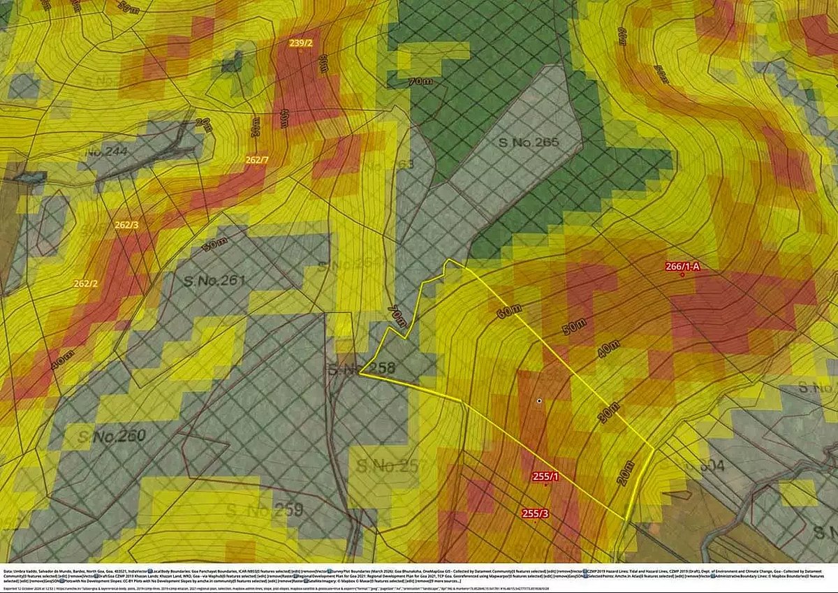
While Goa’s laws are clear that no construction is permitted on slopes over 25%, the government is relying on data from private surveyors and engineers to determine which slope fits this criteria. Activists said that these surveyors can have a conflict of interest as they are hired by applicants seeking permission for hill cutting and that the lack of independent verification of this data is diluting protection given to steep slopes.
We have asked the Chief Town Planner Vertika Dagur if these plans are independently verified and how they assess these discrepancies. We will update this story when we receive a response.
In 1997, Goa amended the TCP Act and introduced Section 17A that prohibits cutting of hills, with an aim to reduce the state’s vulnerability to landslides.
India is among the top four countries with highest landslide risk, with nearly 12.6% of the land prone to landslides. Most vulnerable areas are the mountainous region of the North-Western Himalayas, the Sub-Himalayan terrain of the North-East, the Western and Eastern Ghats. A landslide is essentially the failure of a slope triggered either by natural causes like excess rainfall, flooding, earthquakes or anthropogenic activities like deforestation, hill cutting and excessive development.
Many states, such as Maharashtra, Himachal Pradesh and Tamil Nadu, have introduced provisions restricting development on slopes and hills with an aim to keep the slopes stable and reduce landslide risks. But Goa explicitly demarcates areas with slopes where development is prohibited, a feature that activists said helps in pushing back against illegal hill cutting.
Between March and August 2026, ISignal analysed publicly available data on these conversions, examined physical files of some of the applications and interviewed environmentalists, architects, land surveyors and land policy researchers to understand how Goa managed to protect its slopes and how that protection is being systemically dismantled.
How is construction on hilly land governed
Since the 1980s, tourism and real-estate development have exerted tremendous pressure on the land in coastal stretches of Goa. Over the last two decades, this demand has further soared, largely driven by the desire for a ‘second home’ among metropolitan Indian elites and Goan ex-pats. This demand further surged during the COVID-19 pandemic and has been steadily shifting from saturated coastal areas to hilly areas of the state’s midlands.
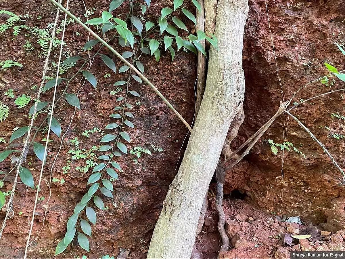
Similar pressures on land due to tourism and rampant real-estate development is a recognised threat to the stability of hills and mountains in India, and are known triggers for major landslides. But, India does not have any specific national laws governing what kind of development is allowed or prohibited on these hills.
Instead, state governments and local body authorities regulate these activities. And all of them have different parameters and metrics.
Himachal Pradesh does not allow real estate projects on slopes that have an incline of more than 45° and bans hill cutting of more than 3.5 metres. In some areas of Maharashtra, building construction is prohibited on a hilly site with more than 20% gradient. Tamil Nadu, in its hill stations, only allows trees to be grown on land with more than 1:3 gradient, prohibiting all other uses.
Other states like Sikkim and Meghalaya, and cities like Manali, Dalhousie and Mussourie, regulate what percentage of the total plot area can be developed, the idea being that a larger footprint would mean more cutting of slopes and trees and hence increased instability.
But enforcing these restrictions has been a major challenge. In a 2014 paper on building regulations in hill towns, authors said that some hill towns do not have appropriate regulations needed for achieving systematic development in environmentally sensitive hill areas. And in towns where regulations exist, they are not followed or monitored efficiently.
In Goa too, the regulations face multiple implementation challenges but active citizens movements have been pushing the government to safeguard the hills.
The provision to protect Goa’s hills was introduced because of multiple letters that an activist wrote to the government in the 1980s, said Tahir Noronha, an architect, researcher and a doctoral student at the University of California, Berkeley. “Shridhar Kamat was writing letters every six months for almost a decade saying that we need to stop construction on hill slopes and that will save us from landslides,” he said.
The Planning and Development Authority (Development Plan) Regulations issued in 1989 prohibited construction on Goa’s slopes with a gradient of more than 25%.
Further, Kamat’s letters resurfaced in 1990s after a major landslide in Panaji’s Altinho, prompting the formation of a fact-finding committee to figure out the cause of the landslides. “The committee in its report said that caution must be exercised on any hill steeper than 10% slope, and there should be strictly no construction on hills steeper than 25% slope,” said Noronha.
Based on this report, in 1997, the TCP act was amended and Section 17A was introduced. It said that no hilly or sloping land over 10% gradient can be cut or filled up without prior permission from the Chief Town Planner.
Regardless of the provisions, hill cutting continued unabated, said Noronha. “Because the State government never maintained records of hilly land, action was taken only on the basis of complaints. Often after the hill was cut. They would inspect the site, file a complaint, and not pursue the matter further,” he said, adding how such action also depended on the location of the violation. The government would be more strict in cities such as Panaji while being lax with permissions in remote villages.
In 2007, when the Regional Plan 2021 was being drafted, the planners attempted to resolve enforcement issues. Using maps from the Survey of India to identify all the locations with slopes over 25% gradient and marking them in green zigzag lines as No Development Slopes in the spatial plan.
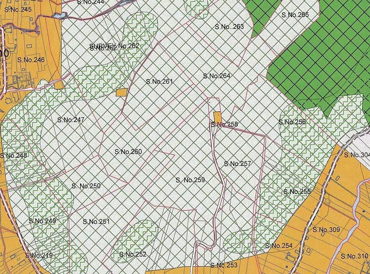
This helped community members seek accountability and push against illegal hill cutting. “The government itself has shown that these slopes are 25% slopes. So, if a construction comes up there, you have a solid proof by just showing a copy of the regional plan. It also showed investors and property owners that certain lands were undevelopable,” Noronha said.
“The logic was that the law can be compromised, the officers of the law can be compromised, but the map can never be compromised,” said Noronha.
The “legal” pathway for hill cutting
In July 2024, a major landslide in Kerala’s Wayanad killed 373 people and injured another 200, making it one of the deadliest natural disasters in the state’s history. During an assembly discussion on rampant development and hill cutting, Goa Chief Minister Pramod Sawant called the landslide in Kerala an “eye-opener” for Goa and said, “We cannot compromise on their [the hills’] stability. A system will be developed to report and monitor hill cutting in the state.”
In June 2026, the TCP Board approved an increase in fine for illegal cutting, introducing a graded system with fines ranging from Rs 50 lakh to Rs 1 crore.
While ministers have reiterated that cutting slopes over 25% is prohibited, the government diluted the legal protection for such slopes by introducing a circular that disregarded the Regional Plan and instead began relying on contour maps submitted by private companies and land owners as sole evidence, said Noronha.
Section 17A gives the Chief Town Planner the powers to give permission for hill cutting. In 2023, the Chief Town Planner issued a set of additional guidelines allowing land owners to apply for such permission, for developing on slopes between 10 and 25% gradient.
An applicant has to attach a contour plan with a 1-metre interval as proof to show that the gradient falls within this bracket. A contour plan is a map of the plot that shows how steep a slope is using lines connecting points at the same altitude. It is a data-generation exercise, where errors can get introduced at multiple stages.
The process begins with a land surveyor who walks around a piece of land with a machine that captures coordinates and elevation. They collect data from points chosen at regular intervals and then upload them to a design software like AutoCAD. The software then joins the points at the same altitude, creating the lines that show the contours of the area.
An interval of 1 metre means that the software will draw a line for every 1 metre of difference in altitude. The distance between these lines is used to calculate the gradient of the slope. The ratio between the interval and the distance shows how steep or flat that area is. For example, if the distance between two lines in a 1 m interval map is 4 metres, then that area has a slope of 1:4 or 25%. So, the closer the lines are, the steeper the slope of that specific area is.
As per the guidelines, these plans have to be created by ‘Chartered Surveyors, Architects or Engineers’ registered with the TCP department. These professionals are hired by the applicants and hence can have a vested interest to manipulate these contour maps to show a lower gradient, said Dean D’Cruz, an architect who was also a member of the Task Force for the 2021 regional plan. “The client will tell the architect to not worry and they will do what they want [with the contour plan].”
ISignal spoke to a land surveyor, who helped create a contour map for a major real estate project, on condition of anonymity. He showed us how the map was later altered by the architect to show a lower slope gradient. “If you look at these lines,” he said, showing two lines on the AutoCAD interface, “The distance between them is less than 4 metres, meaning that this area has a slope of over 25%. But, later when the map was submitted to the TCP department for approval, many of these lines were deleted. So the distance between the lines widened and the slope gradient went down.”
Despite these loopholes in the process, the TCP department does not independently verify these maps.
A contour map’s accuracy is also dependent on how granular the data is. A map with a lower interval will have more lines and hence more details. The Survey of India maps that the regional plan used has a 10-metre interval and is from the 1970s, while a contour plan that the applicant submits is supposed to be more recent and granular with a 1-metre interval.
In November 2025, the Bombay High Court dismissed a petition filed by residents of Sancaole against technical clearance given to a mega real-estate project by Bhutani Infra. One of the key objections of the petitioners was that the contour maps were manipulated to show the gradient to be just under 25%. The High Court said that it did not find any discrepancy in how the slope was computed and that the plans submitted by the company were made based on surveys carried out on location with a “total station survey” with 90-95% accuracy, as compared to the Survey of India data.
In the last two years, the TCP board has used similar maps submitted by land owners as proof for the gradient of a plot and approved 240 applications seeking conversion of plots that have No Development Slopes into settlement zones, data collated by the citizen’s group show. The total area to be converted based on these applications was over 20 lakh square metres. The board recommended most of these conversions because the slopes were found to be within “permissible gradient”.
Noronha and a group of volunteers have been examining slope conversions that have received provisional approvals and have found several inconsistencies. Many have unsigned contour maps, some applications claim that the plot has a “gradual slope” but does not specify the gradient and some do not even have a contour plan attached–yet, in all of these cases, the Town Planning Board gave provisional approval.
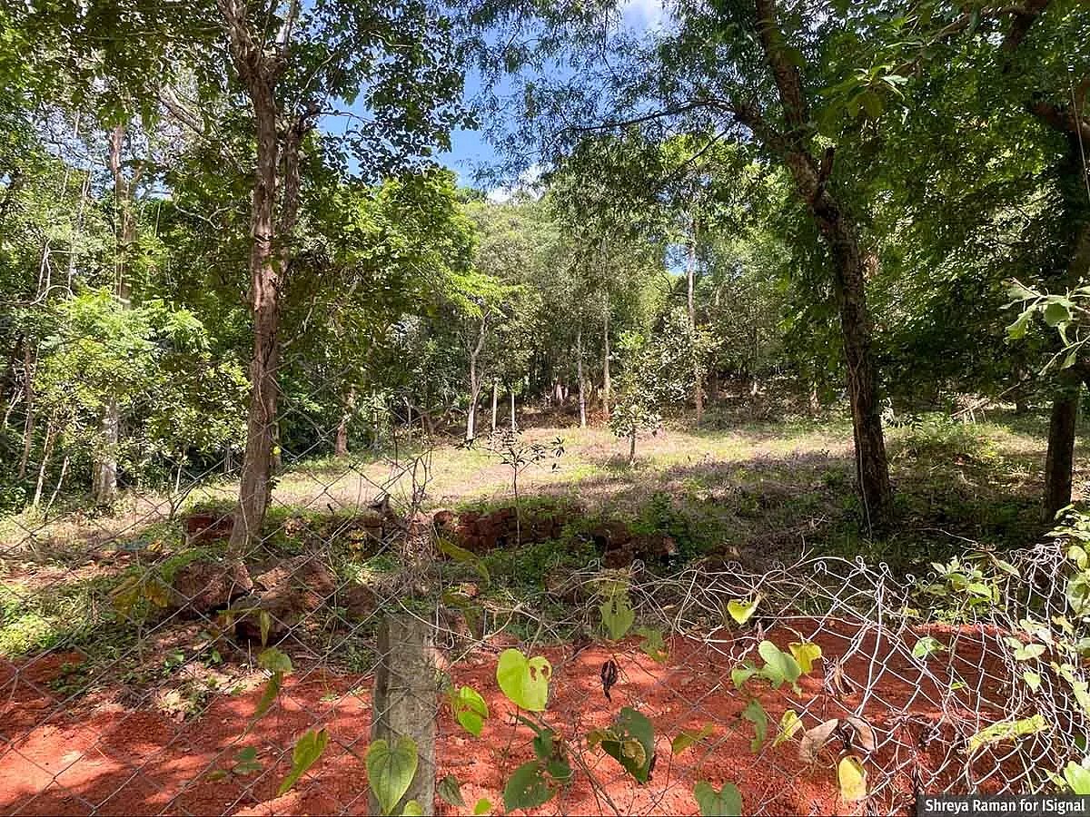
“Unlike in the past, most of the constructions on hills now are “legal” because now they have permissions from the Goa government. Even if it is a hill, even if an authoritative document of the government [Regional Plan] says it is a hill, a private engineer hired by the landowner declared it not a hill and the state of Goa is going with whatever the property owner says.”
The case for a new regional plan
Since 2018, three consecutive amendments–Sections 16B, 17(2) and now 39A–have been introduced in Goa’s TCP Act to allow plot-by-plot conversion of zones in the regional plan. The rationale behind all of them have largely been about errors or anomalies in the plan and the need to correct them.
In September 2024, the TCP Minister Vishwajit Rane told the Times of India that a lot of people have benefitted from Section 17(2). “Some people’s lands were originally settlement areas which were made into paddy fields and orchards and put in different zones,” he had said in September 2024.
“While there may be some such cases, the minister, when challenged in the assembly, has not been able to give any detailed maps or listing of what he alleges,” said Solano DaSilva, an assistant professor in the Department of Humanities and Social Sciences at BITS Pilani, Goa and one of the authors of the book The Great Goa Land Grab. He added that the plan does need corrections but not the ones that the minister claims.
The plan, in its list of issues that need new policies, stressed on the need for updating the plan using a GIS system to make the data geo-referenced and spatially linked. It also said that certain departments have only provided them with incomplete data.
“We did not have GIS then, we only had survey maps and had to collate data from each department separately. All of the layers came one-by-one and we did the best we could given the limited resources,” said D’Cruz, the architect who was also a member of the Task Force for the 2021 regional plan. “That was 20 years ago and that support system was not there. Now we have better technology.”
The year mentioned in a regional plan is the horizon year until which the planning had been done. Activists and researchers have also been demanding an update.
“This regional plan was planned up to 2021. The natural process for a new plan ought to have started, which the government has not done,” said former chief justice of Allahabad High Court, Justice Ferdino Rebello, who also has been leading a citizen’s movement called “Enough is Enough” to protect Goa’s environment and people’s rights. A new plan would have to undergo public consultation and would be a more transparent process, all of which the government has bypassed by introducing amendments like Section 17(2) and 39A, he added.
In January 2026, Justice Rebello shared a 10-point Citizen’s Charter of demands aimed at protecting the environment and ecology of the state. The first point of the charter called for immediate halt to hill-cutting by declaring them the heritage of the people.
“Goa is dependent on rain water. The rain which falls percolates into these hills and filters out into streams and rivers. If we cut down all the hills, and the trees then where will we get water from?” asked Justice Rebello, “And we also have soft laterite soil. If trees are cut, then the soil will fall down and we will have landslides.”
Risk for landslides also depends on the composition and integrity of the lateritic soil. “The iron and silica makeup of lateritic soil changes based on distance from the coast. With acid rain, lateritic soil weakens; with certain types of plants, lateritic soil becomes stronger,” said Noronha, while stressing the need for location-specific soil sampling and testing before permissions are given. “Because, in places where the laterite is degraded, even disturbing a 10-15% slope could risk landslides,” he added.
Moreover, the current provisions are not enough, said D’Cruz. “Most of the slopes in Goa have gradients closer to 1:4 (25%) and they are highly ecosensitive forested patches. So, to protect these borderline cases, it is better to consider 1:5 (20%) as the threshold,” he said.
“If we can only correct the RP-2021 in the manner it was sought to be corrected. By ensuring all of the slopes and paddy are marked out properly. Tenanted lands should also be marked because they also cannot be used for non-agricultural purposes. The government has all this data. If we can only do that, we will be able to protect most of Goa,” said DaSilva.
This report is republished with permission from ISignal, formerly IndiaSpend, a data-driven, public-interest journalism non-profit. It has been lightly edited for style and clarity.